Platform Architecture

Platform Functions
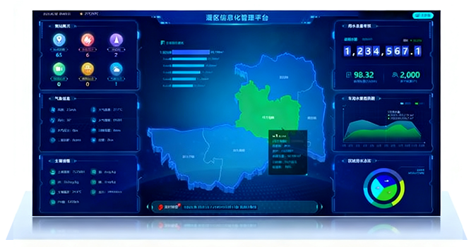
1.Smart Irrigation District in One Map
Based on the irrigation district's GIS, it aggregates and displays the operation status of irrigation district projects and water resource allocation, enabling macro-level mastery of irrigation district information.
Irrigation District Water Measurement and ManagementReal-time display of water level and flow data of main, branch, lateral, and farm canals at all levels, and analysis of water resource allocation and users' water consumption.
2.Smart Irrigation and Drainage for Balanced Water Resource Allocation
Comprehensively analyze canal water levels, irrigation needs, and meteorological soil moisture, and link to control pump station operations and gate openings, realizing unattended operation of pump stations/gate stations.
3.Agricultural Water Price Reform Management
Including tiered water price setting, water right trading, water right allocation, etc., with complete functions and simple operation.
4.Informatization of Daily Management in Irrigation Districts
According to the daily management needs of different departments in the irrigation district, data is statistically analyzed, and various standardized reports are automatically generated to improve management efficiency.
5.Soil Moisture and Meteorological Monitoring
Monitor soil moisture and meteorological data to analyze irrigation needs, assist irrigation district managers in formulating water use and distribution plans for the irrigation district, and improve the efficiency of water resource utilization.
6.Inspection + Work Order Management
Conduct online inspections of the operation data and equipment status of the entire irrigation district project. Immediate alarms are triggered in case of abnormalities, and work orders are automatically dispatched.
7.Mobile APP
Support online inspections, viewing alarms, receiving work orders, and managing work order progress.


.png)
.png)


